|
Sunday March 22nd, Beggars Bridge, Glaisdale , led by Rachel Carlin |
|
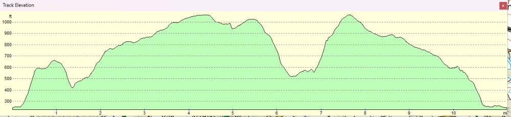
gpx file 13 walkers 11.5 miles 1824ft ascent |
| Mapping data supplied by Rachel Carlin |
| Photographs submitted by Gary Norman |
| Back markers: Gary Malcolm/Norman Barclay |
|
Always stay in touch with the person in front, and the person behind |
|
|
|
Map created on gpsvisualizer.com using Topo map(4Umaps.eu) |
|
|
|
*COPYRIGHT of photographs vests in the photographer identified in the report. |
 |
 |
 |
 |
 |
 |
 |
 |
|
Meet at Beggar's Bridge, near Carr End, Glaisdale. There will be a coffee/tea break down near the stream before Grange Head farm, so bring a flask if you wish. The lunch stop will likely occur after Egton High Moor. The walk is around 16km (10 miles) long and will be muddy at times. It is recommended to wear sturdy boots and gaiters or waterproof trousers. Limited parking is available in the lay-bys near to Beggar's Bridge, so please car-share where possible. An undulating walk with stunning moorland views. The walk begins at Beggar's Bridge, where we climb out of Glaisdale through farmland, then head up onto Egton High Moor. We head down into Glaisdale itself, with beautiful views across the valley, then up onto Glaisdale Ring via Red House. We then head back to the starting point via the scrubland near the church.
|
|
|